Published On Apr 13, 2023
Claim Your FREE GUIDEBOOK to Using Drones in Construction 👇
https://bit.ly/42MY2b9
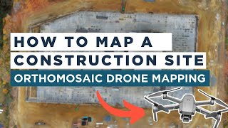
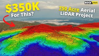
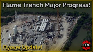
In order to verify earthwork volumes throughout this 160-acre mixed-use development site, a LiDAR drone mission was determined to be the most time efficient, accurate, and cost effective method for mapping Cambridge Constructors & Engineers’ entire project. After analyzing the elevation data, it was discovered that over 100,000 cubic yards of additional dirt was needed to complete the job – saving the company considerable time and money in rework.
►Resources
Review the Full Case Study - http://bit.ly/41ucMdp
►Our Must-Have Drone Equipment Checklist
✅ Budget Friendly Ground Control Points (GCPs) - http://bit.ly/3nAT2pH
✅ Most Reliable SD Card for Drone Mapping - http://bit.ly/3lZOhWn
✅ Heavy Duty Landing Pad - http://bit.ly/3zt1hXA
✅ Collapsable Orange Safety Cones - http://bit.ly/40Tr2fp
✅ OSHA Certified Safety Vest -http://bit.ly/3KsycSt
✅ Wind Speed Anemometer Gauge - http://bit.ly/3ZCaYO5
✅ Best Flight Planning Tablet - http://bit.ly/40Dci4q
✅ Handheld VHF Airband Transceiver - http://bit.ly/40AyLPP
►About The Drone Life
The Drone Life is an industry-leading UAS service provider that provides turnkey aerial data solutions nationwide. We proudly specialize in the industrial, environmental, renewable, and construction industries. Our team consists of highly experienced, dependable, and licensed drone professionals that are committed to safety, quality, and customer success.
Website - https://thedronelifenj.com
LinkedIn - / the-drone-life-nj
Instagram - / thedronelifenj
Facebook - / thedronelifenj
TikTok - / thedronelifenj
#construction #earthworks #drone