Published On Apr 15, 2024
For educational purposes only. If you live in the affected areas, please stay tuned to your local National Weather Service office for the most accurate and up-to-date information.
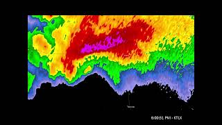
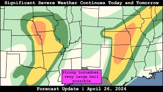
An outbreak of severe weather is expected to begin today across the Plains before shifting east into the Midwest/Mid-South tomorrow and Wednesday. The SPC has outlined an Enhanced Risk (level 3/5) across southern South Dakota and much of Nebraska down into western Kansas. Supercells are expected to fire in multiple areas by early evening, including ahead of the surface low/along the warm front and along the dryline. Very large hail is possible, and an intense low-level jet will yield a strong tornado threat with any discrete supercells from central Nebraska into southwest Kansas.
The threat shifts east on Tuesday; the SPC has outlined an Enhanced Risk (level 3/5) for parts of Iowa, Missouri, and Illinois. As long as destabilization and storm mode cooperate, supercells with very large hail and tornadoes, perhaps strong, are possible in this area. A separate area of severe storms may occur along the stalled Pacific front across eastern Oklahoma and western Arkansas. What happens on Tuesday will modulate what happens on Wednesday, but severe storms are possible on Wednesday across Indiana, Ohio, Kentucky, and a small sliver of Tennessee.
Become a Patreon member today to support the channel: / convectivechronicles
Facebook: / convectivechronicles
X: / convchronicles
Instagram: / convectivechronicles
Contents
0:00 Introduction
3:37 Current observations
11:49 Discussion of today's setup
33:49 Discussion of Tuesday's setup
45:06 Discussion of Wednesday's setup
47:11 Wrap-up