Published On Apr 18, 2024
For educational purposes only. If you live in the affected areas, please stay tuned to your local National Weather Service office for the most accurate and up-to-date information.
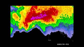
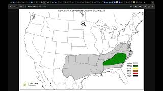
The SPC has outlined an Enhanced Risk (level 3/5) today from central Missouri eastward to the western Ohio Valley and a broad Slight Risk (level 2/5) extending down into south Texas. A cold front will progress east, initiating storms along it by mid-afternoon. A mix of supercells and line segments are expected across the Enhanced Risk with an all-hazards threat, including very large hail and a couple tornadoes. Farther southwest, the cold front will overtake the dryline, yielding a few storms with a risk for damaging outflow winds and very large hail in a strongly unstable environment but more weakly sheared environment. Some folks have compared the environment to that which spawned the infamous Jarrell, TX, F5 tornado in 1997, but we'll discuss why it's not a good analog in the video.
My Jarrell breakdown video: • The Jarrell, TX, F5 Tornado of May 27...
Corfidi (1998) paper on Jarrell: https://www.spc.noaa.gov/publications...
-----------------------------------------------------------------
Become a Patreon member today to support the channel: / convectivechronicles
Facebook: / convectivechronicles
X: / convchronicles
Instagram: / convectivechronicles