Published On Aug 10, 2021
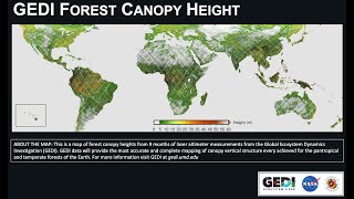
The Global Ecosystem Dynamics Investigation (GEDI) is a full-waveform lidar instrument that produces detailed observations of the three-dimensional structure of the Earth’s surface. GEDI precisely measures forest canopy height, canopy vertical structure, and surface elevation which enhances our understanding of global carbon and water cycle processes, biodiversity, and habitat.
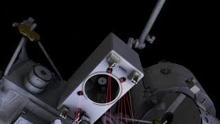
On the International Space Station (ISS), 254 miles up, orbiting the Earth once every 90 minutes, GEDI uses waveform Lidar to record elevation and canopy data. Three lasers split into four beams (firing 242 times per second) are dithered to 8 tracks, 6 meters apart, with 25-meter footprints every 60 meters. That's 968 footprints per second. Laser energy traveling almost 300 million meters per second reflects off higher surfaces first, then lower surfaces shortly after. The tiny delay is detectable by GEDI's telescope sensor which records the intensity of the reflection over time and uses the known speed of light with other variables to calculate a waveform documenting the reflective density of the footprint at various elevations, representing the surface below. Users can process these data into maps illustrating ground elevation, canopy height, and other surface characteristics.
What's new with GEDI Version 2? Sub-orbit granules, spatial metadata, improved geolocation, best algorithm by default, and data layer updates and additions.
GEDI is the first of its kind to provide high-resolution laser ranging observations optimized for lidar measurements of the Earth’s forests and topography at the highest resolution and densest sampling of any other lidar instrument in orbit. GEDI data are available at NASA’s Land Processes Distributed Archive Center (LP DAAC). Historical and forward processing is ongoing. Data will be available from March 2019 to the present.
To learn more about GEDI data, please visit the LP DAAC website:
https://lpdaac.usgs.gov/data/get-star...
For more information on the GEDI Version 2 improvements, please read:
https://lpdaac.usgs.gov/news/release-...
The LP DAAC is one of the NASA Earth Observing System Data and Information System (EOSDIS) DAACs and operates as a partnership with the United States Geological Survey (USGS). It is located at the USGS Earth Resources Observation and Science (EROS) Center in Sioux Falls, South Dakota. The LP DAAC ingests, archives, processes, and distributes NASA Earth science land processes data and information.
Have questions about GEDI data? Contact the LP DAAC: https://lpdaac.usgs.gov/lpdaac-contac...