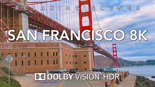
Published On Mar 18, 2024
#explore #travel #roadtrip #beautiful #relaxing #california #amazing #4k #driving
- Camera 🎥: DJI Osmo Action 4 - https://amzn.to/49yviFt (Amazon)
- ND Filter: K&F Concept - https://amzn.to/3SZ8VUd (Amazon)
- Micro SD Card: SanDisk | https://amzn.to/3T9DUNm (Amazon)
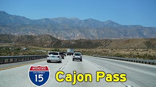
- San Bernardino is a city and county seat of San Bernardino County, California, United States. Located in the Inland Empire region of Southern California, the city had a population of 222,101 in the 2020 census,[8] making it the 18th-largest city in California. San Bernardino is the economic, cultural, and political hub of the San Bernardino Valley and the Inland Empire. The governments of El Salvador, Guatemala, and Mexico have established the metropolitan area's only consulates in the downtown area of the city.[9][10] Additionally, San Bernardino serves as an anchor city to the 3rd largest metropolitan area in California (after Los Angeles and San Francisco) and the 13th largest metropolitan area in the United States; the San Bernardino-Riverside MSA.
Furthermore, the city's University District serves as a college town, as home to California State University, San Bernardino.
San Bernardino was named in 1810, when Spanish priest Francisco Dumetz led an expedition through the area. In 1839, the Mexican government granted Californio ranchero José del Carmen Lugo the right to settle the area, which was formalized when he was granted Rancho San Bernardino in 1842. Following the American Conquest of California, the community on the rancho incorporated as a city in 1854.[11] The city grew significantly in the late 19th century as a commercial hub at the crossroads between Southern California and the American Southwest. Today, San Bernardino is an important hub for the Inland Empire and Southern California.
- Route 15, consisting of the contiguous segments of State Route 15 (SR 15) and Interstate 15 (I-15), is a major north–south state highway and Interstate Highway in the U.S. state of California, connecting San Bernardino, Riverside, and San Diego Counties. The route consists of the southernmost 289.24 miles (465.49 km)[2] of I-15, which extends north through Nevada, Arizona, Utah, Idaho, and Montana to the Canada–US border. It is a major thoroughfare for traffic between San Diego and the Inland Empire, as well as between Southern California, Las Vegas, Nevada, and the Intermountain West.
South of its junction at I-8 in San Diego, the highway becomes SR 15, extending 6.13 miles (9.87 km)[1] to I-5, about 12 miles (19 km) from the Mexican border. This segment was initially signed as a state route instead of an Interstate, but it is being upgraded to Interstate standards so it would become part of I-15 in the future. Including this segment, the entire length of Route 15 is 295.37 miles (475.35 km)[1] in California.
I-15 has portions designated as the Escondido Freeway, Avocado Highway, Temecula Valley Freeway, Corona Freeway, Ontario Freeway, Barstow Freeway, CHP Officer Larry L. Wetterling and San Bernardino County Sheriff's Lieutenant Alfred E. Stewart Memorial Highway, or Mojave Freeway.