Published On Feb 9, 2024
When sci-fi technology meets the industrial revolution... the result is unlike anything you've ever seen before!
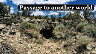
In May of 2022, the EBT Foundation partnered with Wingfield Scale and Measure to complete Lidar scans of the East Broad Top Railroad's two out-of-service tunnels. At the time, we were able to share some photos of the drones conducting these scans and many of our fans asked to see the final product. As excitement grows over our expansion south to Saltillo, we decided that now is the perfect time to share the completed Lidar scan of the Sideling Hill Tunnel.
It is important to note that the Sideling Hill and Wrays Hill tunnels sit along the EBT's mainline south of Saltillo, where our current strategic plan for expansion ends. In the hope that restoration beyond Saltillo becomes feasible in the long term, we conducted these scans to help us understand the current condition of the tunnels and the overall scope of work necessary for their repair. There is currently no timeline for expansion beyond Saltillo.
Drones were used to conduct this work because the exploration of the tunnels is not safe, even by trained professionals. DO NOT attempt to enter these tunnels. Trespassing on railroad property is dangerous, and illegal, and will be prosecuted to the full extent of the law.
#ebtrr #eastbroadtop