Published On Mar 25, 2021
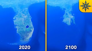
Video shows the elevation trend across the landscape of United States of America mainland by sea level Visualization from normal sea level 0m to the highest point. The Elevation of all the major cities also included in the video.
Note: If all ice on earth melts, the maximum sea level would rise around 70 meters (230 feets).
Website: https://www.worldostats.com/
Related Video
👉UK Flood Map | Sea Level Rise (0 - 1000m)
• Video
Music: YouTube Audio Library
********************
source: https://www.floodmap.net/
********************
Tags:
Effect of sea level rise
USA elevation
Ocean water level rise
USA Cities flood
Elevation Map
How earth would look if all ice melted
Understanding the sea level rise
Sea level rise simulation
Miami sea level
America sea level change
#worldostats #floodmap #USA #sealevelrise