Published On Mar 24, 2020
This video outlines the challenges posed by the depletion of the Ogallala Aquifer in the Texas High Plains, highlighting the overuse of this vital water source for irrigation and its rapid decline. It also emphasizes the need for sustainable water management practices to preserve the aquifer for future agricultural use, discussing the historical context and the aquifer's critical role in supporting the region's agriculture.
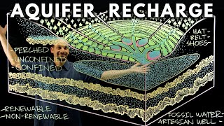
The Ogallala Aquifer is a massive underground, freshwater reservoir that extends across eight states from South Dakota to Texas. Critical for large-scale production agriculture, nowhere is the aquifer more in danger of running dry than in the Texas High Plains.
Lucia Barbato of the Texas Tech University Center for Geospatial Technology explains the Ogallala Aquifer using sophisticated maps of the region. This underground water supply is critical for irrigation tor area farmers and it’s a finite freshwater resource that’s running dry. This is an extended interview from the 30 minute documentary we filmed in 2010 about the efforts of area stakeholders, producers (farmers), scientists, universities and state and federal government agencies, to more accurately measure water usage and find ways to extend the life of aquifer for agricultural purposes.
Watch Water Scarcity For Farmers on the Texas High Plains: • Navigating Water Scarcity: Sustainabl...
Partial Transcript:
This is a challenging land. It always has. It is today. The challenge is that while we are over at the southern end of the aquifer that's a virtually finite water supply. Because of the ability to tap that resource and use it for irrigation. A lot of it's already been used, it's a very rapid rate. We use it far in excess of it’s ability to recharge. And today we're dependent on that for agriculture as we know it. But that's changing, that change has got to come as rapidly as the decline, because we've got to learn other ways of keeping this land productive.
The Ogallala Aquifer extends all the way up into South Dakota, Nebraska, Kansas, and they have a lot more water in some areas than we do here in West Texas, the Ogallala Aquifer in the southern part of Texas is cut off by the, the, the area over here that's been drained and eroded. And over here by the Pecos River. So really this is the only extent, that, that, that's left. So, we're not getting recharged anymore from the Rocky Mountains...
Follow us:
Cooking Up a Story website:
https:///cookingupastory.com
Facebook
/ cookingupastory
Pinterest
/ foodfarmerearth
Cooking Up a Story channel on YouTube
/ cookingupastory