Published On Premiered Feb 3, 2021
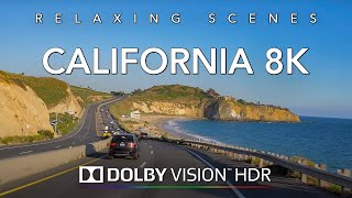
Driving California Pacific Coast [4K] Pescadero to Bolinas through San Francisco Bay area
If you are a fan of road trips, this driving video is for you.
If you like to have a road noise with no music, try this video for background noise!
This driving tour takes you through the California's cities like
Sausaliton, Daly City, Pacifica,
San Francisco Bay Area
Scene from SR 1 near Half Moon Bay at Tunitas Creek Beach
Entering San Mateo County, SR 1 follows the west coast of the San Francisco Peninsula, passing by the marine mammal colonies at Año Nuevo State Park, and the historic Pigeon Point Lighthouse, before reaching Half Moon Bay.
Between Half Moon Bay and Pacifica, the highway bypasses a treacherous stretch known as Devil's Slide via the Tom Lantos Tunnels.
The Golden Gate Bridge, which SR 1 shares with US 101
SR 1 winds along the Marin County coast
SR 1 then becomes a freeway once again at Sharp Park in Pacifica before turning inland to join Interstate 280 in Daly City.
Just short of reaching the City and County of San Francisco, SR 1 splits from Interstate 280, where the road becomes Junipero Serra Boulevard.
Shortly thereafter, the highway makes a slight left, becoming the six-lane wide 19th Avenue; the San Francisco Municipal Railway's M Ocean View streetcar line runs in the median from this point until a junction to a rail only right-of-way near Rossmoor Drive.
SR 1 then turns into Park Presidio Boulevard after it passes through the city's Golden Gate Park. Then after entering the Presidio of San Francisco, it goes through the MacArthur Tunnel before joining US 101 for a fourth time on the approach to the Golden Gate Bridge known as Doyle Drive.
After crossing the bridge and entering Marin County, SR 1 then splits from US 101 again near Marin City, where it leaves the city and, as the Shoreline Highway, returns to a winding, two lane road as it passes over the Marin Hills to rejoin the coast at Muir Beach. After passing Stinson Beach and the Bolinas Lagoon, SR 1 avoids the immediate coastline of Point Reyes National Seashore and the rest of the Point Reyes Peninsula, and instead heads towards, and then along, the eastern shore of Tomales Bay.
Leaving Tomales Bay, SR 1 heads further inland to intersect with Valley Ford Road just north of the Sonoma County border.
It then rejoins the coast in Bodega Bay, where its name changes to Coast Highway past the Sonoma Coast State Beaches.
After bridging the Russian River at Jenner, SR 1 continues to wind along the rugged coast to Fort Ross, Salt Point State Parks, and the planned community of Sea Ranch
Dash Cam Tours
#Driving #LosAngeles
Dashcamtours.com
Check out my second channel with scenic walking tours:
/ povwalks
Follow on Twitter:
https://twitter.com/DashCamToursDot?s=09