1:32:52
Drone Survey Accuracy and how to prove it - WSLS Surveyors' Institute 2024
303 views • 2 months ago
7:08
DJI M350 Review - Surveying Edition: Pros, Cons & Comparison vs. the M300 RTK
5.2K views • 9 months ago
2:47:29
Best Workflows for Successful Drone Programs
402 views • 1 year ago
1:26:59
PPK Processing Workflows
344 views • 1 year ago
1:27:03
How to Pick the Right Drone for Surveying
177 views • 1 year ago
4:15
Should you use Terrain Awareness?
550 views • 1 year ago
1:58:31
Best Practices in Drone Surveying - TAPS 2023
535 views • 1 year ago
6:57
Guide to Aerotas Products & Deliverables
675 views • 1 year ago
2:33:01
Lidar Data Acquisition and Processing - ISPLS 2023
517 views • 1 year ago
2:14:07
Best Practices in Drone Surveying - Alabama Society of Professional Land Surveyors - 2022 Conference
428 views • 1 year ago
1:31:11
Best Practices in Drone Surveying - Florida Surveying and Mapping Society Annual Conference 2022
594 views • 1 year ago
1:22:10
Processing Aerial Lidar Data - Western Regional Survey Conference 2022
459 views • 2 years ago
1:23:44
Making Use of Drone Lidar Data - Western Regional Survey Conference 2022
392 views • 2 years ago
1:24:18
Best Practices in Drone Surveying - LSAW 2022 Conference
480 views • 2 years ago
1:09:58
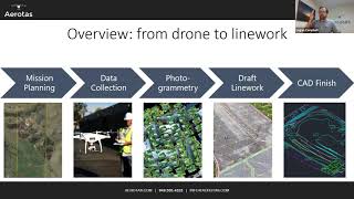
Processing Aerial Lidar Data - LSAW 2022 Conference
322 views • 2 years ago
1:27:05
Making Use of Drone Lidar Data - LSAW 2022 Conference
315 views • 2 years ago
1:53:02
WSLS2022 Drone LiDAR Data
388 views • 2 years ago
53:22
About Aerotas Products and Services - WSLS 2022 Vendor Session
204 views • 2 years ago
6:05
DJI M300RTK - Smart Controller Overview
9.8K views • 2 years ago
1:33:52
Workflows for Combining LiDar and Photogrammetry Data - 2021 Western Regional Survey Conference
57K views • 3 years ago
1:56:27
Drone Data Processing for Surveyors
33K views • 3 years ago
1:53:52
Why Flight Operations Matter
4.3K views • 3 years ago
1:40
Aerotas - Drone Data Processing for Surveyors
2.9K views • 3 years ago
3:24
Using KML Files to Plan DJI Phantom 4 RTK Missions
33K views • 3 years ago
1:19:39
Aerotas at UCLS 2020
135 views • 4 years ago
1:05:32
Aerotas at the 2020 WCCS Survey Conference - Part 2
106 views • 4 years ago
1:06:45
Aerotas at the 2020 WCCS Survey Conference - Part 1
98 views • 4 years ago
3:40
DJI Geofencing; The Other Barrier to Flight in Controlled Airspace
446 views • 4 years ago
33:06
Pix4D Product announcements 2019 Pix4D User Conference
250 views • 4 years ago
30:42
Pix4D Conference: Measuring and Certifying Survey-Grade Accuracy with the Phantom 4 RTK
504 views • 4 years ago
Load More